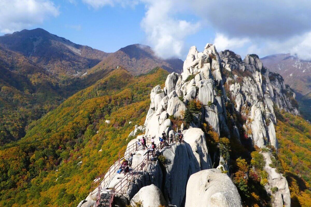
Seoraksan National Park
Where granite peaks, Buddhist temples and Korea’s mountain history meet
Discover Seoraksan’s granite ridges, Buddhist temples, waterfalls and historic mountain routes, where centuries of religious heritage meet one of South Korea’s most celebrated natural landscapes.
INTRODUCTION
Introduction
Seoraksan rises in north-eastern South Korea near Sokcho, stretching across parts of Sokcho, Inje and Yangyang in Gangwon State. Its steep granite peaks, deep valleys and forested slopes have shaped travel, religion and settlement in the region for centuries.
Seoraksan became South Korea’s fifth national park in 1970 and was recognised as the country’s first UNESCO Biosphere Reserve in 1982. Alongside its famous hiking routes, the park preserves Buddhist temples, a Goryeo-era fortress site and long-established mountain paths that connect natural and cultural history.
WHY VISIT
Why Visit Seoraksan National Park?
Seoraksan is one of the best places in South Korea to combine mountain scenery with cultural history. Buddhist temples, historic routes, fortress remains, dramatic granite formations and seasonal landscapes make the park rewarding even for travellers who are not attempting its hardest hikes.
01
Korea’s Iconic Mountain Landscape
Ulsanbawi, Daecheongbong and Seoraksan’s granite ridges form one of Korea’s most recognisable mountain landscapes. Deep valleys, waterfalls and forested slopes create very different experiences across Outer, Inner and South Seorak.
02
Buddhist Heritage in the Mountains
Sinheungsa and Baekdamsa preserve centuries of Buddhist history within the park. Sinheungsa traces its origins to a Silla-period temple founded in 652, while Baekdamsa is associated with both Buddhist practice and the poet and independence activist Manhae Han Yong-un.
03
Fortresses, Passes & Historic Routes
Gwongeumseong preserves the remains of a mountain fortress associated with the Goryeo period, while old passes and valley routes show how people once crossed and used this rugged terrain long before modern roads and cable cars.
04
Hiking for Many Ability Levels
Seoraksan offers everything from temple walks and short waterfall routes to steep summit hikes. Ulsanbawi provides a demanding but popular half-day challenge, while Biseondae and the lower valleys offer gentler ways to experience the park.
HISTORY
A Short History of Seoraksan
Seoraksan’s cultural history is closely tied to Buddhism and the mountain routes of north-eastern Korea. Temples were established in the region during the Silla period, and generations of monks, pilgrims and local communities treated the valleys and peaks as both sacred and practical landscapes.
During the Goryeo period, mountain strongholds such as Gwongeumseong were built or used in response to conflict and invasion. Later Joseon travellers, monks and scholars continued to move through Seorak’s valleys, while temples such as Sinheungsa and Baekdamsa were repeatedly rebuilt after fires and warfare.
In the twentieth century, Seoraksan became increasingly valued as a protected natural landscape as well as a cultural one. It was designated South Korea’s fifth national park in 1970 and became the country’s first UNESCO Biosphere Reserve in 1982, strengthening conservation of its ecosystems and mountain scenery.
KEY HISTORICAL MOMENT
1970
In 1970, Seoraksan was designated South Korea’s fifth national park. The designation marked a major step in protecting a mountain landscape already famous for its temples, granite formations, forests and long cultural history.
TOP SIGHTS
Top Sights in Seoraksan National Park
Seoraksan’s best-known sights are spread between Outer Seorak near Sokcho, Inner Seorak around Baekdamsa and South Seorak near Osaek. Outer Seorak is the easiest base for first-time visitors and contains many of the park’s most famous walks.
1
Sinheungsa Temple
Sinheungsa stands near the main Outer Seorak entrance and traces its origins to a temple founded in 652 during the Silla period. Historic halls, a stone pagoda and the mountain setting make it the park’s most accessible cultural site.
2
Ulsanbawi Rock
Established after the port opened, Ulsanbawi Rock reflects the growth of a Chinese merchant community beside the foreign settlement zones. Its streets combine food culture, migration history and late nineteenth-century urban heritage.
3
Heundeulbawi Rock
Heundeulbawi Rock preserves more than three centuries of medicinal-herb trade. The surrounding market streets and Museum of Oriental Medicine explain how the city became one of Korea’s most important centres for traditional medicine.
4
Gwongeumseong Fortress
Gwongeumseong is a mountain fortress site associated with the Goryeo period, set roughly 800 metres above sea level. A cable car provides the easiest access to the upper area, where stone remains and panoramic views combine history with dramatic mountain scenery.
5
Biryong Falls
Osaek lies on the South Seorak side of the park and provides access to valleys, mineral springs and demanding mountain routes. It offers a quieter base than Outer Seorak and a useful contrast with the busier trails near Sokcho.
6
Biseondae Rock
Housed in a former colonial-era bank building completed in 1932, the Biseondae Rock traces the city’s social, commercial and urban transformation from the late nineteenth century into the modern era.
7
Baekdamsa Temple
Baekdamsa Temple is the city’s best-known traditional market and a lively place to encounter regional foods and everyday commercial culture. It adds a social and culinary layer to an itinerary otherwise dominated by elite houses and institutions.
8
Daecheongbong Peak
Daecheongbong, at 1,708 metres, is Seoraksan’s highest peak. Reaching it requires a long and demanding mountain hike, often involving an early start or shelter planning, so it is best reserved for experienced hikers who have checked current trail conditions.
THINGS TO DO
Things to Do in Seoraksan National Park
Seoraksan is best experienced by combining cultural sites with trails of different difficulty. A temple visit, a granite-ridge hike, a waterfall walk and a quieter day in Inner or South Seorak reveal very different sides of the same mountain.
Hike to Ulsanbawi
Follow the classic route from Sogongwon through Sinheungsa and Heundeulbawi to Ulsanbawi. The final climb is steep, but the granite formations and wide views make it one of Seoraksan’s signature hikes.
Ride to Gwongeumseong
Take the cable car towards Gwongeumseong for an easier high-level view of the park and East Sea. The upper fortress area adds a layer of Goryeo history to the mountain scenery; cable-car operations can be affected by weather.
Walk the Waterfall & Valley Trails
Choose Biryong Falls, Biseondae or another lower-valley route for a less strenuous day. These trails focus on streams, forest and rock scenery rather than exposed summit climbing.
Discover Inner Seorak & Baekdamsa
Travel to Inner Seorak for Baekdamsa and its quiet valley setting. The temple, mountain bus approach and walking routes provide a calmer cultural experience than the heavily visited Outer Seorak entrance.
SUGGESTED ITINERARY
3 Days in Seoraksan National Park
Three days allow enough time to combine Seoraksan’s cultural heritage with one major hike and a quieter valley day. Weather, trail closures and fitness should always shape the final plan, especially on high or exposed routes.
DAY 1
Outer Seorak: Temples, Fortress & Waterfalls
MORNING
Begin at Sogongwon and walk to Sinheungsa before the busiest part of the day. Explore the temple grounds and mountain setting before deciding whether to continue on foot or use the cable car.
AFTERNOON
Take the cable car towards Gwongeumseong if conditions are suitable, then return to the valley and follow the Biryong Falls trail. This gives you both high-level views and an accessible forest-and-waterfall walk in one day.
EVENING
Finish at Baekdamsa Temple for dinner and local specialities. An evening walk through the centre provides a more contemporary contrast to the formal heritage sites of the morning.
DAY 2
Ulsanbawi & Heundeulbawi
MORNING
Start early from the Outer Seorak entrance and follow the trail past Sinheungsa towards Heundeulbawi. The lower section provides a steady warm-up before the much steeper climb beyond the rock.
AFTERNOON
Continue to Ulsanbawi, allowing plenty of time for the stairs and exposed upper section. The summit viewpoints are the reward, but turn back if weather, wind or trail conditions make the route uncomfortable.
EVENING
Return to Sokcho or Seorak-dong and keep the evening relaxed. If your legs need a rest, use the following day for Baekdamsa rather than another major summit route.
DAY 3
Inner or South Seorak: Baekdamsa, Osaek & Mountain History
MORNING
Begin at Baekdamsa Temple and the nearby Independence Gate area. The exhibitions provide essential context for Japanese colonial rule and the independence movement.
AFTERNOON
Alternatively, travel to South Seorak around Osaek for shorter valley walks and mountain scenery. Experienced hikers may consider a Daecheongbong route only after checking current access, weather and the required hiking time.
EVENING
Finish in Sokcho, Yangyang or your mountain accommodation. Seoraksan also combines naturally with Sokcho’s coastal history or Gangneung further south along the East Sea.
WHERE TO STAY
Where to Stay near Seoraksan National Park
Where you stay has a major effect on early starts and transport. Seorak-dong is best for immediate access to Outer Seorak, while Sokcho offers the largest choice of hotels and restaurants. Osaek and the Baekdam area suit visitors focusing on other sides of the park.
01
Seorak-dong
The most convenient base for early hikes from the main Outer Seorak entrance. Staying here reduces morning travel time for Ulsanbawi, Sinheungsa, Biryong Falls and the cable car.
FIND STAYS IN SEORAK-DONG →
02
Sokcho
Sokcho offers the widest choice of accommodation, restaurants and evening activities. Local buses and taxis connect the city with the Outer Seorak entrance, making it the best all-round base for most visitors.
BROWSE HOTELS IN SOKCHO →
03
Osaek & South Seorak
Osaek is useful for visitors focusing on South Seorak, hot-spring areas or demanding routes towards Daecheongbong. It is quieter than Sokcho and better suited to mountain-focused stays.
FIND STAYS NEAR OSAEK →
04
Baekdam & Inje
The Baekdam and Inje side is the best base for Inner Seorak and Baekdamsa. It works particularly well for travellers who want quieter valleys and Buddhist heritage rather than the busiest Outer Seorak routes.
FIND STAYS NEAR BAEKDAM →
GETTING AROUND
Getting Around Seoraksan National Park
Seoraksan is spread across several valleys and administrative areas, so there is no single transport hub for the entire park. Most first-time visitors use Sokcho and the Outer Seorak entrance, then make separate trips to Osaek or Inner Seorak if needed.
On Foot
Once inside the park, walking is the main way to explore. Trail difficulty varies enormously, from easy temple approaches to long summit routes, so choose trails according to weather, experience and fitness.
By Bus
Local buses connect Sokcho with the main Outer Seorak entrance and serve some surrounding areas. Services to Inner Seorak and South Seorak are less convenient, so journey planning matters if you do not have a car.
By Taxi
Taxis are useful for early starts from Sokcho, especially when bus schedules do not match your hiking plans. Longer transfers between different sides of the park can become expensive.
By Car & Intercity Transport
Sokcho and nearby towns are reached primarily by express or intercity bus from Seoul and other cities. A rental car is useful for combining Outer Seorak, Osaek, Baekdam and wider Gangwon destinations, though peak-season parking and traffic can be heavy.
BEST TIME TO VISIT
Best Time to Visit Seoraksan National Park
Seoraksan is open through much of the year, but trail access can change because of weather, fire-prevention closures or mountain conditions. Spring and autumn are the most popular hiking seasons, while winter requires appropriate cold-weather experience and equipment.
Spring
APRIL TO MAY
Spring brings milder temperatures, flowering trees and comfortable conditions for the long outdoor walks required at the Temple and Heundeulbawi Rock. April and May are particularly pleasant, although public holidays can bring noticeably larger domestic visitor numbers.
Summer
JUNE TO AUGUST
June to August is warm, humid and affected by seasonal rain. Valleys and waterfalls are attractive, but heavy rain can change trail conditions quickly and exposed summit hikes require careful weather checks.
Autumn & Winter
SEPTEMBER TO MARCH
September and October bring cool air and spectacular autumn colour, making this the park’s busiest season. Winter can be beautiful but requires proper equipment, and some routes may be restricted or hazardous.
BEST OVERALL TIME
April to May & late September to October
Mid-spring offers comfortable hiking and fresh foliage, while late September and October provide the park’s famous autumn scenery. Always check current trail notices before setting out.
Next Destinations
Sokcho
Sokcho is the natural gateway to Outer Seorak and adds port history, coastal scenery, markets and twentieth-century stories connected with migration and division.
Gangneung
Gangneung combines Joseon houses, Confucian learning, literary heritage and the East Sea, making it a strong cultural continuation south along the Gangwon coast.
Pyeongchang
Pyeongchang continues the mountain theme with highland landscapes, Buddhist heritage and the modern legacy of the 2018 Winter Olympics.
Seoul
Seoul provides the main urban contrast to Seoraksan, with royal palaces, city walls and modern-history museums only a few hours away by road.